
TrueView MLS - Dry Hire
Geo Drone Solutions operates across a variety of areas of 'LiDAR'. This includes Drone based LiDAR, handheld SLAM and also Mobile Mapping. This is all equipment that we have here within our South East Qld fleet.
The big benefit for our partners, is that we can work together and put this equipment to good effect.
Geo Drone Solutions offers 'Dry hire' to it's survey based partners, this includes Mobile Mapping.
Mobile Mapping equipment is relatively expensive and complex to use. Given we have this equipment, the software and know how, it makes sense to partner with us before committing to a GeoCue TrueView MLS LiDAR system. The TrueView LiDAR system that we pair with our GeoCue Mobile mapping system is the TrueView 535. Combined with the Wheel encoder, this system offers GNSS accuracy and very dense and clean data.
 TrueView 535 3D Imaging System Upgraded with Three New 26 MP Cameras |  Hornibrook bridge MLS data |
|---|


Who is our Mobile Mapping Pro Kit designed for?
Our Mobile Mapping Pro Kit is perfect for customers who have a good basic knowledge of mapping workflows and are ready to go. This dry hire option includes the TrueView 535 sensor with vehicle mount, Land GNSS antenna, DMI wheel encoder, and POSPac MMS software.

Firmware & software
Vehicle mount
Land GNSS antenna
DMI
(incl. POSPac MMS)
How the DMI, wheel encode, improves data collection and capability
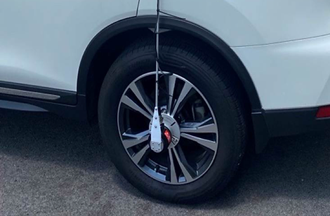
DMI
The DMI is connected to the wheel of the vehicle and connected to the board of the mobile mapping system.
When driving in cities, or in proximity of trees, customers can face GNSS masks due to obstructions such as buildings, tunnels, trees, etc.
The DMI compensates by providing information such as distance.
The DMI is very specific to the wheel used. The circumference of the tyre is used within the calibration settings for the system. Use of the wheel encoder greatly helps to establish and maintain IMU alignment.

TRUEVIEW 535 MLS DRY HIRE
INCLUDES:
-
TrueView 535 3DIS LiDAR System
-
Vehicle Mount (Fixed roof & cabling kit)
-
Land GNSS Antenna
-
DMI wheel encoder with cabling
-
POSPac MMS software (specific for Mobile Mapping)
-
GeoCue LP360 with Mobile Mapping modules
System is kept up to date with respect to hardware, firmware and calibration!
Failed systems are exchanged within 2-4 business days.
Available Rental Commitments:
-
1 Week
-
2 Weeks
-
1 Month
-
3 Months
-
12 Months


Manage your mobile mapping project in real time, using the dedicated application
Easily configure your equipment when switching from drone to mobile mapping data collection.


We recently partnered with our customer DSQ Survey on the Sunshine Coast.
This involved running our TrueView 535 MLS system across various road-based jobs that had previously been surveyed with traditional survey methods. The results met our expectation of GNSS accuracy and displayed the typical TrueView 535 traits of an accurate, dense and refined cloud.
⭐⭐⭐⭐⭐
"I found time today to look at the MLS data and it all came in really well. I was able to check this against a previous survey from 2019, and the verticals came in very tight.
I'm very impressed with the quality and density of the data, especially around the kerbs and median strips."
Trent Park,
Survey Drafter

RENTAL REQUIREMENTS
In order for you to rent our Mobile Mapping system, certain requirements need to be met. Unlike our drone-based dry hire, no CASA qualifications are required for mobile mapping. However, other requirements apply:
-
Your organisation needs to have the survey capability to provide control and process the data, or arrangements made for GDS to post-process on your behalf.
-
Vehicle insurance covering the equipment whilst mounted needs to be in place. Our insurance covers the equipment for in transit insurance whilst being freighted within Australia
-
Your Certificate of Currency will need to list GeoCue Australia as the interested party and will also need to refer to the equipment type and serial number.
-
The DMI is specific to the wheel size of the vehicle being used. We will need details of your vehicle and tyre specifications before rental.
-
For first-time renters, we require a training session (included) to ensure you're comfortable with setup and operation.
