

VI-LIDAR CONTACTLESS SURVEY
8 MP Telephoto + 860,000 pts/sec LiDAR for batch point capture
The ViLi i100's integrated Vi-LiDAR technology revolutionizes surveying by allowing you to capture a single photo and extract multiple 3D coordinates instantly. No need to aim precisely, stay rock-steady, or worry about hand tremors. With an 8 MP telephoto camera providing clear visuals at up to 15 meters with 5 cm accuracy, and a next-generation LiDAR scanning at 860,000 points per second, you can measure hard-to-reach or dangerous points from a safe distance. This eliminates human error and dramatically increases both efficiency and safety in complex environments.
CONFIDENT AND CONSISTENT ACCURACY IN OBSTRUCTION
3× Better multipath auto-filtering with satellite signal analysis
Powered by advanced multi-sensor fusion and real-time satellite path analysis, the ViLi i100 automatically filters GNSS signals affected by multipath errors from obstructions or reflections. The 860,000 pts/sec LiDAR fusion accurately captures 3D spatial data of surrounding buildings in GNSS-obstructed environments, ensuring stable, jump-free positioning with consistent 5 cm absolute accuracy. Whether you're working in narrow alleys, dense forests, or near high-rise buildings, once right, always right.

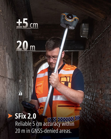
ENHANCED SFIX 2.0 ENGINE
5 cm accuracy within 20 m in GNSS-denied areas
When GNSS signals are completely unavailable, the ViLi i100's SFix 2.0 engine takes over, delivering reliable 5 cm accuracy within 20 meters. Using 860,000 pts/sec 3D laser data and SLAM-based angular constraints, it reconstructs precise positioning without satellites. Trained on tens of thousands of real-world datasets, SFix 2.0 eliminates the need to switch to a total station, offering a true "GNSS anywhere" experience—even under eaves, viaducts, or in dense construction sites. No more workflow interruptions.
3D POINT CLOUD EARTHWORK CALCULATION
Real-time cut/fill volume calculation with 99.98% accuracy
The ViLi i100 enables instant on-site earthwork calculations with exceptional precision. High-precision LiDAR scanning combined with the intelligent LandStar app filters out noise and enables real-time cut and fill volume calculations directly in the field. Simply scan the area, define the boundary, and get instant earthwork results with 99.98% accuracy. No surface contact needed—combining precision, efficiency, and safety in one workflow. This eliminates costly delays from sending data back to the office for processing.


ALL-IN-ONE FLAGSHIP GNSS RECEIVER
Full RTK mode support with LT800 professional tablet included
The ViLi i100 combines all conventional RTK functions with next-generation features in one compact device. Supporting CORS, UHF base-rover, NTRIP, and PPP modes, it's compatible with LandStar software for versatile fieldwork in any setup. The 1408-channel iStar2.0 GNSS engine tracks GPS, GLONASS, Galileo, BeiDou, QZSS, and NavIC signals with exceptional reliability. Dual cameras enable CAD and AR visual stakeout, accelerating workflows by up to 50%. The complete LT800 Rover Kit includes the rugged professional Android tablet, ensuring you have everything needed for professional surveying right out of the box.
PROFESSIONAL-GRADE DURABILITY
IP67 rated, IK08 shock resistant, built for the toughest conditions
Built to withstand the demands of professional surveying, the ViLi i100 features a robust design that performs reliably in extreme conditions. With IP67 ingress protection against water and dust, IK08 shock resistance, and an operating temperature range from -20°C to +55°C, this receiver handles whatever the field throws at it. The high-capacity 9900 mAh battery provides up to 22 hours of operation in RTK rover mode or 5 hours in intensive Vi-LiDAR scanning mode. Quick charge support with 30W PD fast charging means you're back in action quickly, with a full charge in just 5 hours.


OVERVIEW
The CHCNAV ViLi i100 with LT800 Rover Kit is the ultimate all-in-one solution for next-generation surveying. Combining Visual-LiDAR technology, advanced GNSS tracking, and intelligent multi-sensor fusion, it delivers consistent centimeter-level accuracy even in the most challenging environments. From GNSS-obstructed areas with multipath filtering to completely GNSS-denied zones with SFix 2.0, the ViLi i100 ensures you can work confidently anywhere. With contactless Vi-LiDAR surveying, real-time 3D earthwork calculations, and comprehensive RTK capabilities—all paired with the professional-grade LT800 Android tablet—this complete kit represents the future of land surveying technology.
860K
Points per second
LiDAR scanning rate
5 cm
Accuracy in GNSS-denied
areas up to 20 m
99.98%
Earthwork calculation
accuracy on-site
8 MP
Telephoto camera for
contactless surveying
22 hrs
Battery life in
RTK rover mode
IP67
Water and dust
protection rating